Your local weather forecaster may not always be right about the skies in the week ahead, but that doesn’t mean all weather forecasts are a gamble.
Larger, global weather patterns are a much safer bet. Researchers and data scientists can find the patterns in meteorological phenomena and use those trends to predict what the skies will look like in the coming years.
Experts have studied El Nino and La Nina for decades and have a solid understanding of what these weather forces mean for global weather patterns. The two forces are part of the El Nino-Southern Oscillation, which researchers can use their knowledge of the larger phenomena to see what we can expect from the skies in the near future.
The El Niño-Southern Oscillation
Researchers have known about El Niño for decades. As their research progressed, the definition of the weather phenomenon changed, as well.
The term initially described a weak warm water current that ran alongside the Pacific coast of South America in the winter. Today, El Niño describes one phase of the larger El Niño-Southern Oscillation (ENSO); La Niña and a neutral phase are the counterparts to El Niño.
Warmer than average sea-surface water temperatures (SSTs) in the central and eastern tropical Pacific ocean characterize the El Niño phase of the ENSO. High air pressure in the western Pacific comes packaged with El Niño, as does low air pressure in the eastern Pacific. La Niña flips the criteria of El Niño: colder than average SSTs, low air pressure in the western Pacific, and high air pressure in the eastern Pacific.
While the ENSO occurs in the Pacific Ocean, its effects are global. El Niño phases cause heavy rains in northwestern South America from April to October; conversely, La Niña phases induce heavy rain over parts of Asia, primarily in Malaysia, Indonesia, and the Philippines; neutral phases allow global weather patterns to continue uninterrupted.
One of the ENSO biggest influences on global weather comes in tropical storm and cyclones formation. El Niño phases push for more frequent and stronger typhoons in the Pacific, while La Niña increases the power and frequency of tropical storms in the Atlantic.
The duration of El Niño and La Niña isn’t concrete either. Determining if either is active and the length of eithers’ stay has eaten the time for researchers and scientists since the ENSO came under study, and that work continues today.
El Niño o La Niña?
ENSO intervals last about four years on average, but have also concluded after just two years and persisted as long as seven.
Scientists and researchers have tracked the phenomenon since the beginning of the 20th century. Sea-surface temperatures are the biggest indicator of an El Niño, a La Niña, or a neutral phase, and these data points are the focus of the pattern reporting.
Reporting looks at the 3-month average of SSTs in the Niño 3.4 region, a band of ocean roughly 3,000km southeast of Hawaii (at 5oN – 5oS, 120o – 170oW, to be exact). When the average SST of those waters is ±0.5॰C (±0.9॰F) from the areas normal temperature, a phase is in progress. Warmer waters spell an El Niño, and colder temperatures indicate a La Niña.
Currently, the world is experiencing a La Niña phase, and has been since July 2020.
â€
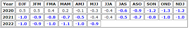
Sea-surface temperatures have largely remained below the average since the July-August-September window of 2020. The trend will probably continue for another few months, a reason for communities and their officials along the Atlantic to focus on their emergency preparedness.
The Forecast: La Niña
Predictions indicate the world’s current La Niña phases will continue through the end of 2022.
The sustained La Niña through this year and its predicted path would make for a rare three consecutive La Niña seasons. Many researchers, however, think the ENSO will shift to a neutral phase before the latter half of 2023.
As we mentioned earlier, La Niña pushes the Atlantic to be more active. As we move towards the end of the year and we hit the traditional peak of hurricane season, we could see an increase in tropical storm development and severity.
What this forecast means for the communities and their leaders is an increased need for preparedness. Extreme storms push communities to extreme conditions that can be tough to tackle in a scramble. Hurricanes are a reality the U.S. South deals with every year, but La Niña conditions could put additional stress on the planners in the region this year.